
Although there are some good transportation connectivity examples in Boca Raton, much still needs to be done to mitigate increasing vehicle use and traffic. A good example of connectivity is in the vehicle road network and an example of poor connectivity is in the bicycle/pedestrian trail network. It’s not surprising, therefore, that Boca Raton residents’ vehicle use is increasing while usage of alternative forms of transportation remain a small fraction of vehicle use.
Transportation connectivity is measured by how well the transportation network connects people to the places they want to go. In the case of vehicles connectivity is relatively seamless; whereas, alternative forms of transportation are rather disconnected.
Boca Raton’s Multi-Use Trails
An example of a disconnected transportation network is the multi-use trails in the City. These trails are designed to separate bicycle and pedestrian traffic from vehicle traffic. Done properly, they are safe and enjoyable for cycling and walking. The following map shows five multi-use trails in the City. They are as follows:
- Black – A1A
- Red – El Rio
- Green – T-Rex
- Orange – Patch Reef
- Blue – Palmetto Park
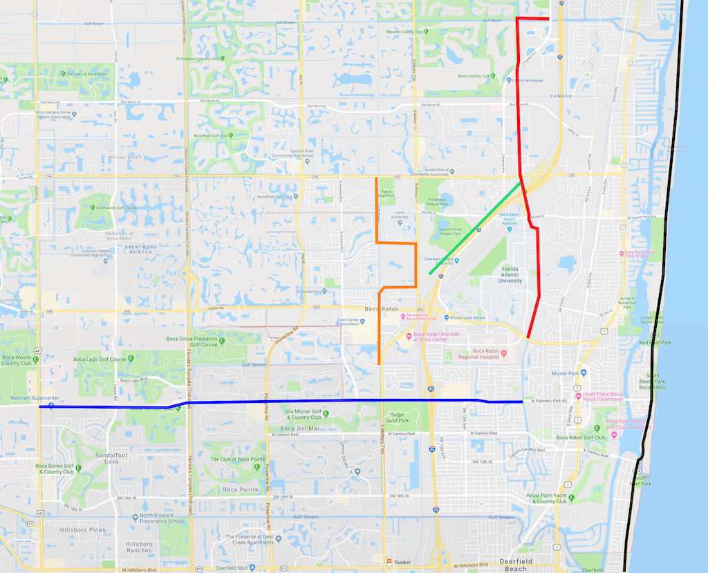
Note in the figure that the only direct connection between the trails is at the Yamato Tri-Rail Station where the El Rio and T-Rex trails meet. In other cases, there are no seamless multi-use trail connections and cyclists and pedestrians must encounter vehicles.
This lack of connectivity is a dis-incentive to use cycling and walking as transportation alternatives to vehicle use. It reduces the safety and enjoyability of these forms of transportation.
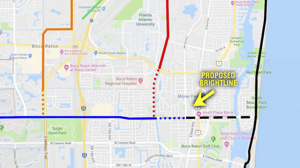
Connection Suggestions
Following is a close-up view of how the five multi-use trails might connect. The Palmetto Park trail could be used as a spine that interfaces to the other multi-use trails as well as other routes in the City. By completing the expansion of the Palmetto Park trail to NW 2nd Avenue, additional transportation options open up for the proposed Brightline Railroad Station. The Palmetto Park trail could also be extended to A1A opening up alternative transportation options to the downtown from the barrier island.
For more information on cycling and walking in Boca Raton please visit the City’s web site.
Additional cycling and walking – oriented maps are included on the site; however, they are about eight years old and need updating.
This article discussed the importance of transportation connectivity. Boca Raton Mayor Scott Singer weighed in on this importance with the following newspaper article comment “History is replete with cities that got left behind because they did not have transportation connectivity.” As shown in the maps above, the City’s multi-use trail network is not connected. Suggestions have been provided for connecting these trails to increase cycling/walking for commuting and recreation.
Multi-Use Trail Connectivity Could Help Reduce Brightline Railroad Station Vehicle Traffic
It is recommended that these improvements be implemented before the proposed Brightline Railroad Station comes on-line to help mitigate the increased vehicle traffic resulting from the station complex.